


Babinda
Babinda – Experience the tropical north’s beauty all in one place.
Babinda North Queensland is located on the Bruce Highway 57 klms South from Cairns at the foothills of Queensland’s highest mountain, Mount Bartle Frere and neighbouring mountain, Mount Bellenden Kerr, only minutes from tropical Bramston Beach and the mystical Boulders and Devils Pool.
One of the wettest places in Australia Babinda vies with Tully for the yearly “Golden Gumboot Award” for the wettest town. There are two claims for the name Babinda one is the local indigenous Australian language word Binda meaning “waterfall” and the other is referring to a word for mountain.
Babinda,
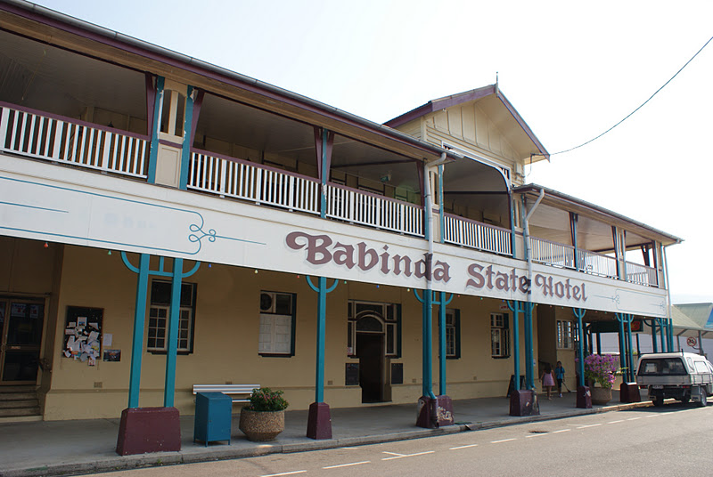
surrounded by sugar cane farms, tropical rain forest, crystal clear rivers and waterfalls is one of the more interesting small towns on the Bruce highway. The Tourist Information Centre is at the entrance to the town and golfers tee off at the Babinda golf course, one of the greenest courses on the Cassowary Coast, the course is on the southern side of the town and visible from the Bruce highway. The Babinda hotel (formally known as the State Hotel) is the only hotel in Queensland built by the state government and opened by the home secretary on the 29th May 1917, a short stroll under the covered walkway will find you at the Munro Theatre built in 1956 and the home of the largest movie screen in Australia. Discover paintings, Aboriginal artifacts and locally produced handmade items at Babinda District Arts and Craft Co-Op Ltd. The Babinda Railway Station beside the Bruce Highway is classical early railway architecture and in its earlier days won many awards for its tidiness and lush ferns hanging from the platform ceiling, the station is serviced by The Sunlander and the Tilt Train travelling southbound from Cairns and northbound from Brisbane.

Babinda is a RV friendly town, a free 48hour overnight park, is located beside Babinda Creek just minutes off the Bruce highway and within walking distance to the town, the amenities block has showers (cold water only) and toilets, dump Site, covered barbeque area and table, park ground and a children’s playground. There are no powered facilities. The park is level, grassed (very green) and capable of accommodating motorhomes, caravans and campers. TV reception is good as the TV transmitter on top of Mount Bellenden Kerr can be seen from the park. A medical service, Babinda pharmacy, ambulance and the Babinda hospital are conveniently located nearby. The Boulders, 7 klms from the town, offers a free 24 hr. stay for self-contained RV’s.
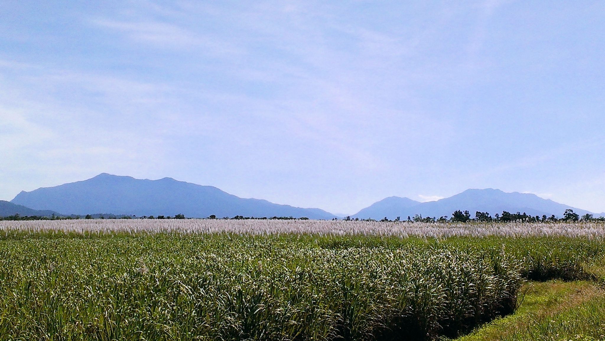
Majestic Mt Bartle Frere and its neighbour Mt Bellenden Kerr towering above flowering sugar cane fields on the tropical Cassowary Coast.
Majestic Mt Bartle Frere and its neighbour Mt Bellenden Kerr towering above flowering sugar cane fields on the tropical Cassowary Coast.
Mount Bartle Frere is the highest mountain in Queensland and the 4th highest in Australia, Height 1,622 meters (5,322 feet)
Mount Bellenden Kerr is the second highest mountain in Queensland, height 1,593 meters (5,226 feet)
The two peaks are part of the Bellenden Kerr range they are totally covered with rainforest from tropical at the foothills to cloud forest at the summit, Mount Bartle Frere is named after Sir Henry Bartle Frere. The indigenous name for the mountain is Chooreechillum, the mountains are in the Josephine Falls section of the Wooroonooran National Park they are made of resistant granite and are remnants of an escapement eroded by the Russell and Mulgrave Rivers. The temperature at the summit of Mount Bartle Frere can be 10 degrees lower than the coast.
Walking Tracks:
 Broken Nose walking track is an 8 hour climb from Josephine Falls takes you 926 meters above sea level with crystal clear mountain streams and huge boulders, lush rainforest, unique birdlife, spectacular views and overnight camping it is an adventure to remember, permits must be obtained, the track is a branch off the summit trail to Mount Bartle Frere. Be prepared for sudden weather conditions, reduced vision due to heavy cloud, heavy rain and temperature drop the track is rated as strenuous. Only well prepared, well informed and very fit experienced walkers should attempt the 15 km climb to the summit of Mount Bartle Frere, allow 2 days for this difficult grade, the entrance to the climb on the coast side of the mountain is at Josephine Falls and the western side is via the Atherton Tableland. Be aware that many have been lost for several days in dense tropical rainforest, there is no water on the summit trail, the temperature will drop and sudden heavy rain may be encountered; be well informed and responsible for your own safety. Remember that you will need to obtain a permit if you wish to camp overnight on Bartle Frere. Permits are available from DERM. Self-registration forms at the beginning of the walks should also be filled in by all walkers.
The traditional owners of the Wooroonooran are the Noongyanbudda Ngadjon Aboriginal people. Wooroonooran National Park was proclaimed a Wet Tropics World Heritage area in 1988 and is one of the wettest places in Australia.
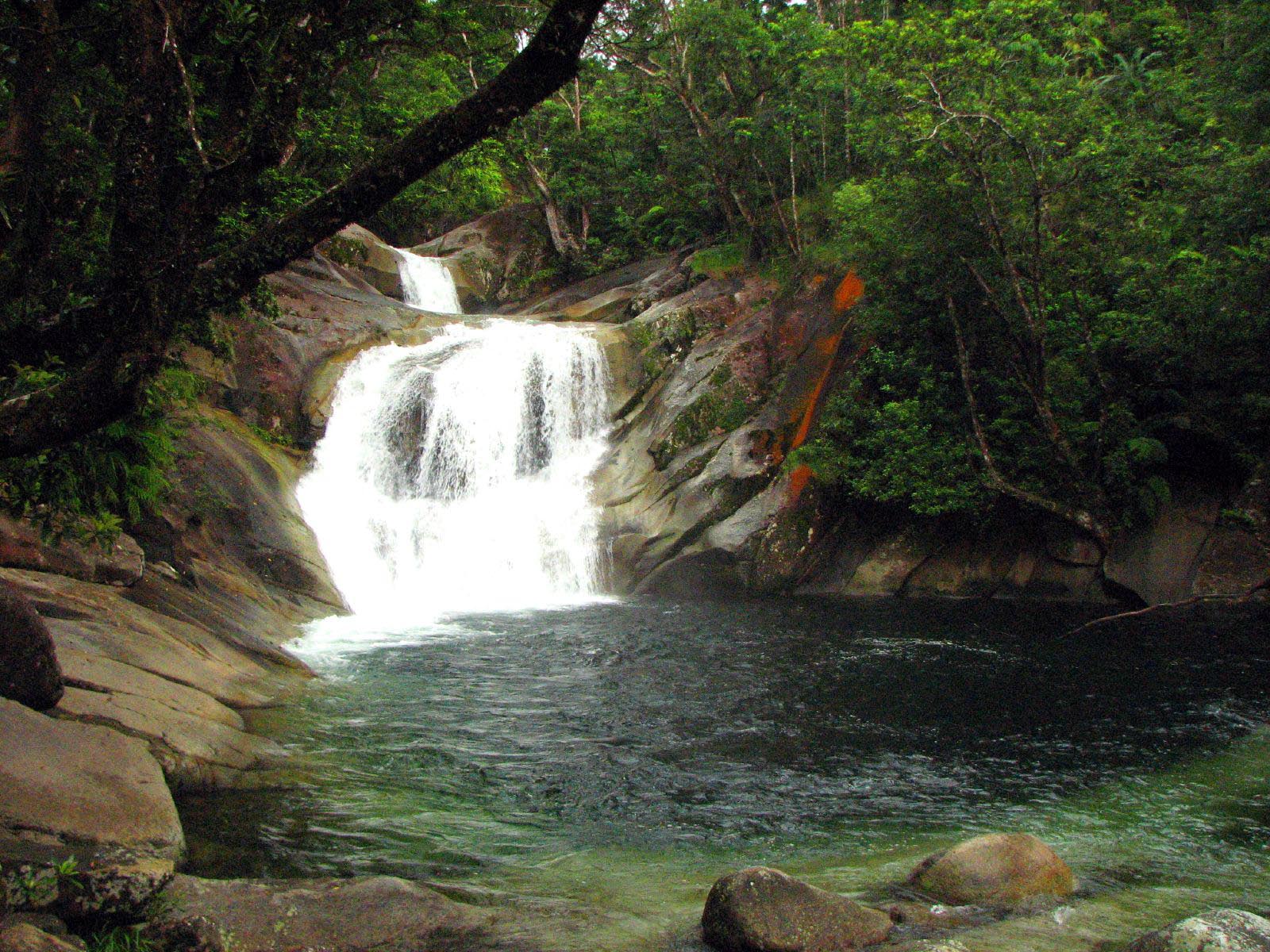
Josephine Falls a short distance from Babinda is the starting point for the Bartle Frere summit and Broken Nose hiking track. To see the Josephine Falls follow the bitumen path, boardwalks and some stairs through the rainforest for an easy 600 meter walk to three lookouts and safe wheelchair viewing platforms of the falls with clean crystal clear cold waters tumbling off Mt Bartle Frere, there is a top and bottom pool, the water is cold and forms a cool microclimate allowing the Atherton Palm and the moisture loving potato fern to grow abundantly. The cool refreshing falls create a perfect spot for a picnic to stay a while and enjoy nature; the sounds of the waterfalls, refresh in the cool waters, take a swim in the swimming hole and natural rock water slide. Josephine Falls is the traditional country of the Ndagjon-Jill.
Amenities include picnic tables, grassed patches and toilets, admittance is free, as it is a National Park no dogs are allowed, be advised there is a potential for flash flooding and sudden raised water levels to occur particularly during the wet season.

Eubenangee Wetlands approximately 14 klms south east of Babinda with over 100 bird species it is referred to as one of the best bird watching locations in the Far North and plays an important role in the regions wildlife, take a 1 kilometre walk to the lookout and experience the fascinating sight of these wetlands with a variety of birds, butterflies, turtle’s crocodiles and an amazing view of Mt Bartle Frere. Sections of the boardwalk contain the last remnants of this type of rainforest with lowland types of vegetation and very rare melaleucas and sedges growing on the edge of the swamp.
Admittance is Free. Warning: Not recommended during flooding as crocodiles will move into flooded areas including the walking track.